Friday, May 17, 2013

Walking in Glenwood

I needed a G for my USA A-Z book. Glenwood begins with G obviously enough. Walking there would also fill in G for my Minnesota A-Z book and also count for Pope County in the Minnesota County record book. So I took off for there yesterday morning.

Tuesday the temperature went to 98 degrees, after temperatures cold enough to create some frost on Sunday morning.  Wednesday was a perfect day, except as I started west big thunder clouds begin to form. However the clouds moved southerly, thankfully, from my destination, about 2 hours away from my home.

Glenwood is a small town, the county seat of Pope County. Pope County is named for General John Pope who was part of an exploring expedition in western Minnesota and up into present day North Dakota. He participated also in the Union side during the Civil War, but did most of his service within the U.S. Military assigned to Fort Snelling here in Minnesota.

Glenwood is named for a glen or valley found on the southeast side of Lake Minnewaska. Minnewaska means dish lake, a lake found in a natural basin.

I was expecting a 6K or 10K walk, but when I got the map out I found the choices were 6 K or 4K. The description cautioned walkers that 2K of the 6K was uphill. That quickly made me think 4K was a good option. It also would balance out a previous 6K I had done and now I could keep track of my total distance in increments of 5 and 10.

 My first clue that I had arrived in lake country was that I was working on my records next to the bait tanks.

 Started off on the walk through the business district, noticing there were benches along the area, ready for someone to sit.

I turned right and soon was walking past the ambulance service for the county and then was soon by the hospital. I decided to go off route and walk a bit along the lake. That's what caused me to walk by the sign below. The combination of the two statements made me laugh.


Soon I was on Lakeshore Drive. The first thing I noticed is that homes along this are were very modest. No McMansion built here.

 This photo shows only a very small portion of the lake.


The photo above is an attempt to show how clear is the water. The picture starts at the bottom with sand and then when it becomes darker that is water over the sandy lake bottom. Finally one can see the filmy reflection of clouds in the water.

I continued to walk through a residential area and found where the large houses are.


These are blocks away from where one would have lake views. The only thing I guess is that 100 years ago "views" were not as prized as they are now. Also, perhaps right along the shore of the lake was a very cold place in the winter. It is a somewhat large lake and nothing would have stopped the north wind whipping over the lake.

Soon I was done with the walk and decided to follow the signs to the county historical museum. What a find!

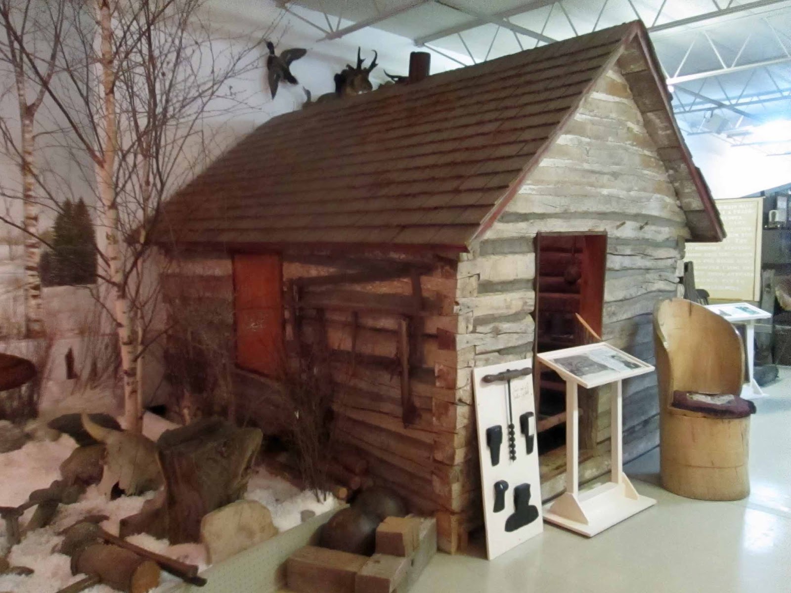
The first part of the exhibits are about who lived here in the 18th and 19th centuries. One thing that was new to me is a fur trapper's cabin. One can't live in Minnesota for very long without knowing the early Europeans here were fur tappers and traders, but this is the first time I've seen how they lived.


One really can understand how small was this cabin when looking inside. There is a stove in the center and two bunks on the back side. To the right, out of the picture, is a plank along the wall that served as a table.


A major collection in this museum is a collection of American Indian folk art. A woman from Pope County worked as a teacher in American Indian schools for much of her career and collected all these objects during their career and sent them home to her mother. She decided to donate all these things to the Pope County museum rather than to museums in Washington, D.C. The volunteer curator said there are about 500 objects in the collection and about 300 on display.

Here's a sample of what I saw.

 Ivory carvings -- these figures are about 3 inches high and made from either whale bone or tusks or tusks from walrus. This is/was done by those who live in very northern area of present day Alaska or present day Canada.

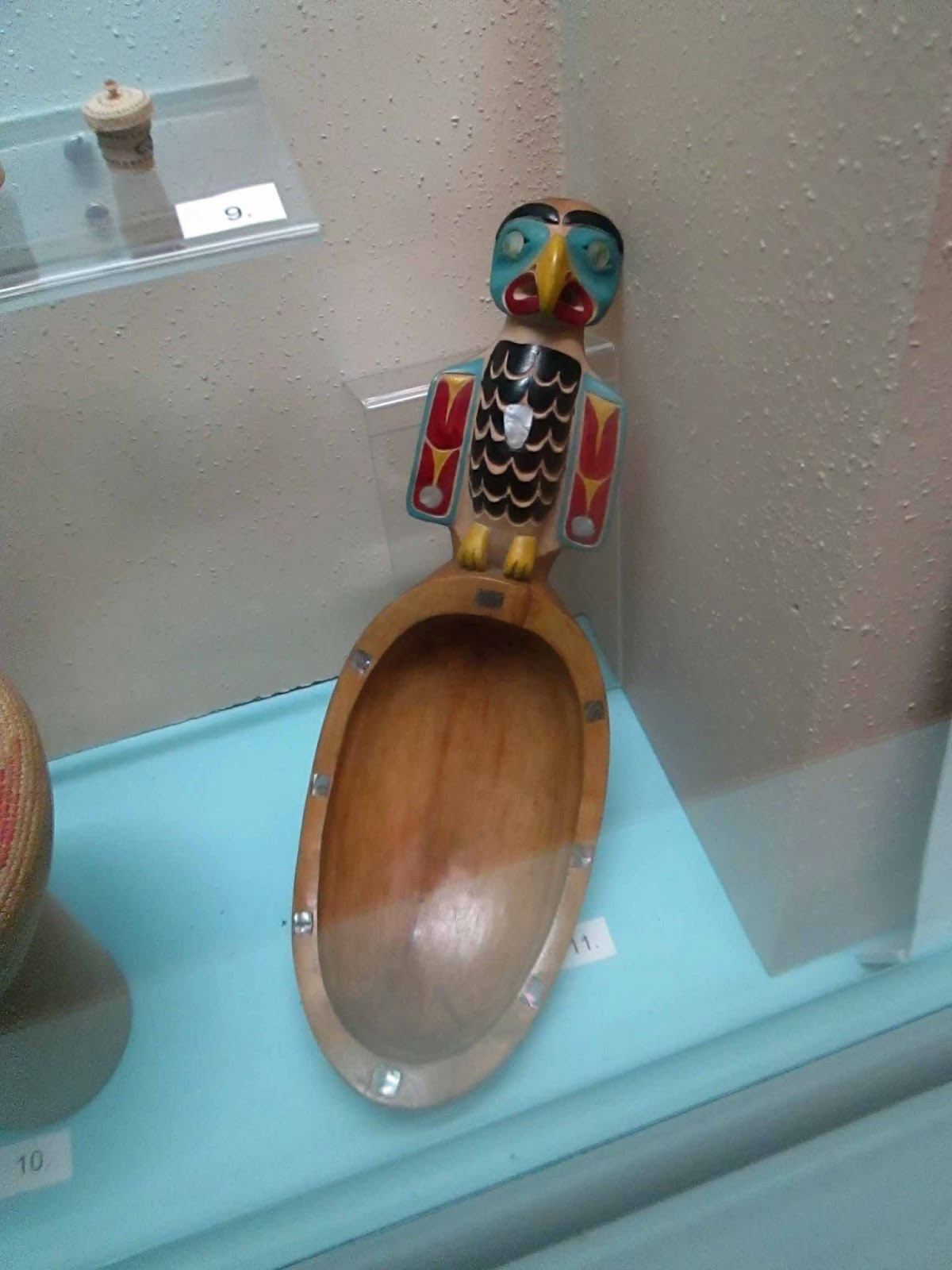
Above is a potlatch spoon. Potlatch was practiced by indigenous people who lived in present day Canada or present day Alaska, but along the Pacific Ocean.

Further south, in areas now part of present day Washington State or Oregon, in the rain forest areas along the Pacific Ocean, the Klamath people made these hats to protect their heads from scratches and other injuries as they walked through the forest.

Many readers may already be familiar with Navaho jewelry. The Navaho live in southwest states.

Above is something I've never seen before. Box turtle shells are laced together and filled with pebbles. American Indian women in the southeast fastened these to their legs while dancing -- the instrument making percussion sounds.

These gloves are associated with American Indians living in the midwest and western states of the United States. Bead work is also found in women's clothing as well as in jewelry.

This is truly a terrific collection and I'd never heard of it before, and would never have found it had I not gone there to walk. That is another benefit of walking -- one finds all kind of new things, even in one's backyard.

This museum had a few buildings outdoors too.

This is what we always called a country school. It served children in 1-8 grades, usually high school students went to "town school."

Scattered about on the desks within the school were many old books. I was intrigued with the cover on this one.

The copyright is 1944 and was surprised to see a helicopter on the cover, for I didn't think helicopters were very prominent yet at this time.

An old Episcopal church, built in 1894, is also found on this site.


The windows over the altar were quite glorious in the spring sunlight.


By this time I was hungry, but the usual things such as Dairy Queen weren't calling to me. I had heard about a special restaurant in this town and simply couldn't find in my walk. I decided to do the first 30 miles of return to home and stop at the first major intersection at some restaurant.  On the way out of town I missed a turn and that's how I accidentally found the Penny Diner, the restaurant for which I'd been looking.

This is a restaurant associated with a new motel in this community. And when in a diner, have diner, have diner food.

Here's a great chili dog. Haven't had one in years!

A great day in Glenwood -- surprised all around.


Thursday, May 16, 2013

Walking in York

I've been working on my USA A-Z walks and that's what brought me to York, NE to get Y.  I did this walk with a friend, a most unusual activity for me, because I usually walk alone. That made 10K go by very quickly, but I find on the other hand, that I didn't take very many pictures.

We arrived at York about mid-day, in fact started out around 12 Noon, perfect weather for a walk.

By mistake we missed a corner to 2nd Street, but then after another block my friend looked left and said, "That's a great restaurant." Consulting our maps we found we could turn on 6th Street and end up at much the same place. After walking a bit, we were glad for this mistake because  it took us down a street of huge, beautiful old homes.

There were many, many and this one took my eye because of the blue, which is one of my favorite colors. (After returning home we did a search on the Internet trying to understand the source of the wealth that built these houses, mostly during the first  years of the 20th century. All we could determine is that once York had many small manufacturing companies -- perhaps that created the wealth.)

Nearby I found a beautiful fence with a spring garden surrounding it.


I also liked this sculpture in front of the public library. It reminded me of a similar sculpture in Chanhassen, MN. (See April posts for walking in Chanhassen.)


Our walk took us around a city park also displaying spring flowers.


 Then we entered the York College campus.


The new copper roof on the Prayer Chapel looked stunning against the clouds.

Our walk then literally took us out into the country. We walked about 4K on farm roads and then found ourselves at the county fair grounds. Benches under trees were a welcome sight! We enjoyed a bit of rest here.

A few more steps brought us to the 4-H Building with a historical marker about the start of 4-H in Nebraska.


Soon we were back on 5th Street and the route took us right by the Chances R restaurant. We stopped for a wonderful lunch. So glad my friend was with me, for even had I walked by, I might not have stopped, not realizing what a treat this restaurant is.

Once done we had only 3 blocks to walk to the ending point.We were sitting down to lunch at 2:20, so we walked the 10 K is just a bit more than 2 hours, allowing for our rest at the county fairgrounds. Not too bad for two grandmothers!


Thursday, May 9, 2013

Visiting Museums in Lincoln

Part of my reason for being in this area is to do a walk in York, NE. My friend said if I could wait until tomorrow than she could go with me. Good plan, for this morning was cloudy and cool. Tomorrow can only be better.

Instead we visiting two museums in Lincoln. Our first stop was the Nebraska History Museum. One exhibit is about the Terri Lee Dolls that were made here in Lincoln for awhile. The exhibit shows a young mother had the idea for a doll, and went into business with her aunt, who rather took over and left the young mother without much say in the business.

The first dolls came out in 1946. They were first made with ethyl cellulose. Each face was hand-painted. They were to be the same and yet each is just a bit different.


If you look carefully you will notice the doll in the upper picture has lower lid eyelashes while the doll on the bottom does not.

This company was a leader in make dolls for African-American kids. The first dolls from the company were sold in 1946 and these dolls were ready for the market for Christmas, 1947.

Another exhibit involves Nebraska's activities during 20th century wars.

Above is a Patriot truck manufactured in Nebraska during World War 1. Below is a scooter, also produced in Nebraska during World War II. This scooter was designed to be dropped by parachute to troops behind enemy lines.

Our next stop was at the Pho Factory, a Vietnamese restaurant, for lunch.

This is a beautifully decorated restaurant and oh my! is the food good.

Our next stop was Lux Center, a small art gallery. It presently has an exhibit called Hammer, Anvil, and Stirrup -- actually the bones in an ear. The objects in the exhibit all make sounds.

Here is a video of one. I had to hold the camera and make the sounds at the same time, so the video is a bit jerky. Sorry.

This exhibit is really fun! A great day in Lincoln.

A Stop at Winnebago

I traveled from Sioux City towards Fremont, Nebraska where I planned to do another walk. On the way I went through Winnebago, NE, the town within the Nebraska Winnebago Indian Reservation. I was surprised to see Ho-Chunk on signs for I associate this with groups in Wisconsin, but some later study on the Internet helped me understand that Ho-Chunk are also in Nebraska, having been forcibly removed here from Minnesota territory. This happened even though the Winnebago were neutral during the time of the Dakota-USA war. I also learned that Winnebago is the name given to this group by the Algonquin tribe. Europeans encountered the Algonquin first and so adopted the name, Winnebago, rather than Ho-Chunk which is what this group calls themselves.

I turned off the highway, first following a sign to Little Priest Tribal College. 

Follow the link above to learn more about this tribal college.

I worked my way back to the school building and parked on a side street.

While taking this picture a man came out of his house and called to me, "Hey! Did you see the buffalo too?" Wanting him to understand I wanted this picture for an English teaching project, I walked over to explain to him what I was doing. Later I thought I should have told him there are buffalo in Poland. I'm sure that would have surprised him!

Nest he asked if I had gone to the Statue Garden.  I told him I had seen a sign for it, but didn't understand what it meant. He went on to explain that the tribe is divided into clans and these statues explain that.

I went back to this area and was glad I did. The tribe had and has a very wise way of managing its community.

The statues were arranged in large circle. Above is a representative view of the Bear Clan. The Bear Clan are responsible for activities pertaining to the earth, including police/peace-keeping functions.

The Elk clan members are responsible for actions pertaining to the maintenance of fire. Certainly before the advent of electricity this would have been an very important function.


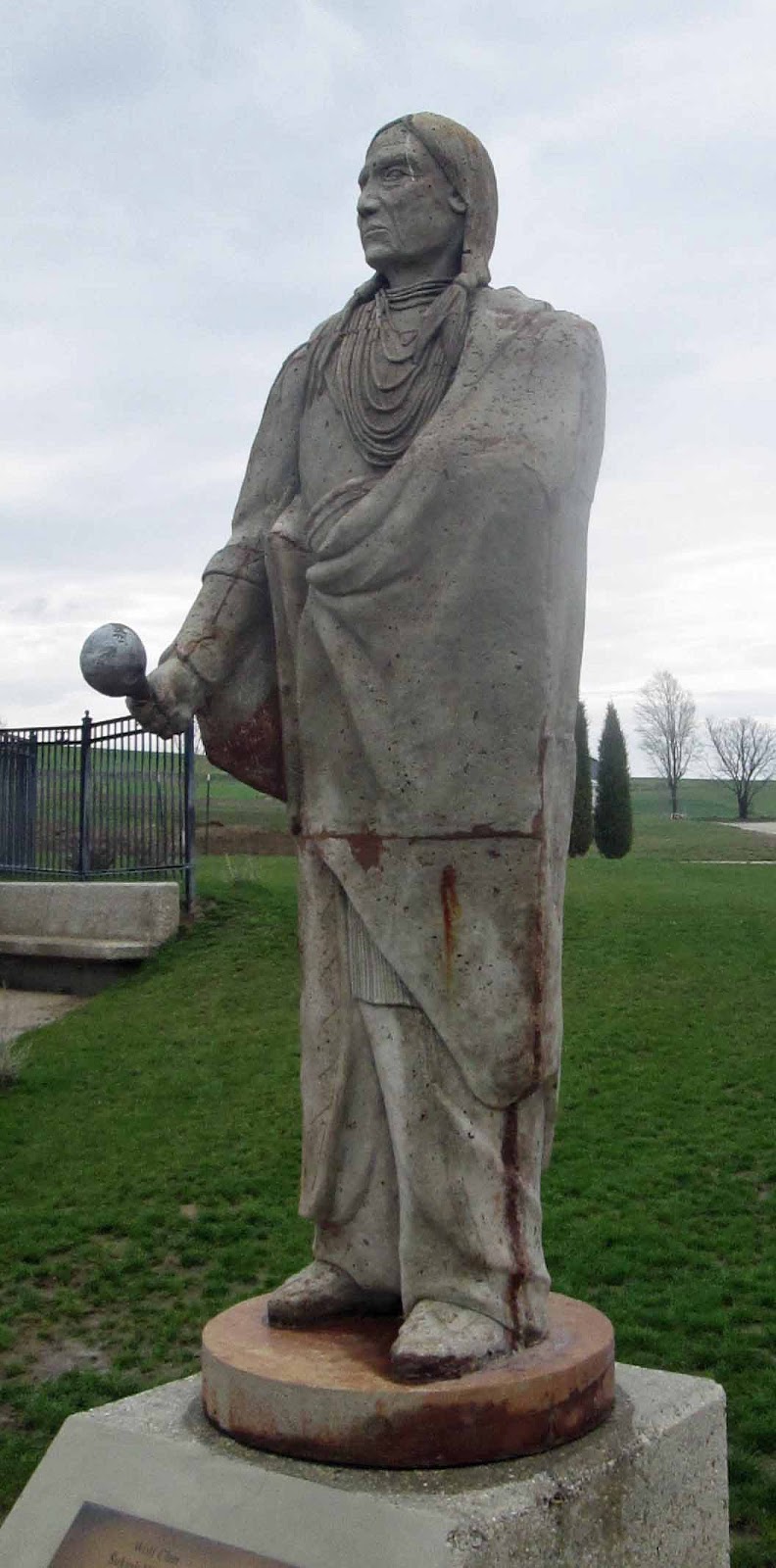
The Wolf Clan is and was in charge of public health and safety.

There were about 10 of these statues -- I'm not posting all of them. I'm certain you can get the idea of how the clans take care of the community.

I was so glad that the gentleman had suggested I double-back and visit the Statue Garden.

Near the Statue Garden I saw a nice playground.


Also there were new apartment buildings in this area. 

I had driven through this area about 10 years ago, and it was obvious the area is now more prosperous. Yes, this group does have some casinos, but also if you follow the link at the beginning of this blog, you will learn the tribe operates a development corporation that does activities ranging from construction to accounting to human resource work. This corporation is doing business in 10 states as well as three foreign countries.

It was raining when I got to Fremont, didn't do the walk, went right ahead to Lincoln, but I'm so glad I went by this route, for it was certainly a good stop in Winnebago.


Wednesday, May 8, 2013

Walking Along the Missouri River

I made a trek to the Sioux City area to do a 10K walk. I searched for a walk in a city that starts with N and when I discovered the walk in the Adam Homestead and Nature Preserve it sounded very interesting. The walk starts with N because the Nature Preserve is located in North Sioux City, South Dakota.

It was a 20 minute drive from my hotel room to the nature preserve. The directions said to look for the big white barn and there it was.


 This structure, fairly new construction, operates as a visitor center and office for the park. I walked in and couldn't find anyone. I looked around in corners and other usual places for the walk box and couldn't find it. Outside was a school group and I thought the staff was probably with the children. I walked out and found a park ranger. She said she would be bringing a group of children in soon and would help me then.

It was really fun to be around these kids. They were probably 4th graders. They were so enthusiastic about anything they found. It's good to see "city kids" getting out in nature.

After getting registered I headed out with the map and followed a trail to the Homestead. I learned this property had been given to South Dakota by Maud and Mary Adams. Fitting that I came to this place. Both of these women were nurses, and both nurse educators: one served for a time as the Dean of Nursing at South Dakota State University and the other headed the nursing program at Morningside College, here in Sioux Falls.

Their grandfather was a Union soldier in the Civil War and used his benefit to homestead to get this land.
 This is the Broussard Cabin, moved here from a nearby area to show the type of cabin settlers built upon arrival. The Adams cabin didn't survive.

Nearby was the house built in the late 19th century.

 This house has been renovated for living in the 21st century, but the sign about the house showed a picture of it in the early 20th century and one could see it was certainly the same house.


Of course a farm needed to have a barn, and of course at this time, all barns were painted red.

Within this museum area is another house, the Shay-Adams House.
Since Adams is part of the name, I guessed this home belonged to a relative. This house was moved onto the farm to prevent the drifting sands of the Missouri River from covering it. (More about that later in this blog.) Near this house, too I found bluebells.


These are one of my favorite early spring flowers.

This area also included a church.

This church originally was built 11 miles away, dedicated in 1906. All the members were from Stavanger, Norway and Norwegian was spoken within the church.

The last building moved here is a school house.

I was wondering where to find the River Loop trail all the time walking around here. Decided to walk back to the Visitor Center to ask directions.

 On my way I found this noisy goose.

By the Visitor Center I found poles marking trails that I had missed and was soon off on the walk.

The walk was on a limestone covered trail through light forest, sometimes with cornfields on one side.

After about 45 minutes of walking I was glad to find a blind.
 I was ready for a rest after walking continuously for more than an hour. And a blind is good for finding out why my phone is telling me to pay attention. Thought it might again be a student in a panic, but no just announcing normal e-mail arriving.

And then suddenly the trail changed and the area looked as if I had arrived at a desert.

 I had thought about walking as far as  the river overlook for my first rest, and was so glad I didn't. As you can see above it is totally drifted with sand.

Maybe you can see why I thought I had arrived in a desert.

Along; the shore I found this lovely and interesting wind-borne sculpture.

And here's what the river shore looks like. I finally understood all the stories I had heard about the drifting sands of the Missouri River.

I slogged through sand for about another five minutes and then I back into the light forest area. I stopped to rest at another blind further down the trail. Then finally I was walking across Cottonwoods Crossing and then it was only a short walk back to the Visitor Center.

This was really a great walk. 


Tuesday, May 7, 2013

From Saint Paul to Sioux City

Yesterday I took an afternoon drive from Saint Paul to Sioux City, Iowa. I didn't see any snow, but many places there is a lot of standing water in the ditches, probably left there from recent snow melts.

Agriculture is very delayed. In the long drive I saw only two farmers out in the fields doing anything, and those were on the Iowa/Minnesota border.

While driving my phone told me I had mail and wondering if I was hearing from a student in a panic. So I stopped at a rest stop along Highway 60. Yes, a student was in a panic, but later when I opened up the computer I found she had done the assignment she thought she had missed.

At this rest stop I spent a bit of time enjoying the birds at the bird feeder.


Miles down the road red train engines caught my eye. I double-backed through the side streets of the little town of Hinton, IA to take this photo.

Really sharp looking!

Many things in this part of the state carry the name, Floyd. Floyd was the quartermaster of the Lewis and Clark expedition. He died in August, 1084 in this area, the only member of the group to die during the expedition. It is now believed he had a ruptured appendix, a health condition that defied treatment on top of bluff over the Missouri River in 1804.

Now the next story will be a 10K walk in this area.