I got tired of talking about Minnesota and in some of the previous years I've done a presentation about other things such as Disney World and my 2014 trip to Bolivia. This year I decided to go back to Minnesota and will hope there is not another volunteer on the same team from Minnesota. Often there is more than one person from Minnesota and that is another reason I've started to do other subjects.
I can't talk about Minnesota and St. Paul without making reference to the Mississippi River. The river forms both the west and south border of St. Paul. And if you are surprised about south, this is one of few or perhaps the only place where the Mississippi flows for a bit from west to east rather than north to south.
I lived along the Mississippi when I lived in Winona and have lived within 1-4 blocks of the river during most of the time I have lived in Saint Paul. I thought the pictures library on my computer would have lots of pictures or that I could copy some off my blog -- my blog has photos that are held on two different computers. Well, I didn't find much that I wanted so early in Friday evening -- yesterday -- I enjoyed an early supper with my older daughter and then we took off to take some pictures. I thought I would share the photos here too.
But first, I wondered how the river got its name. I did a Google search and learned it comes from the Europeans' efforts to pronounce the Chippewa Indian words --Misi Zibi, which means Great River. How did a name from this northern area prevail? Probably because the Mississippi River begins in what is now northern Minnesota. The head waters are in a protected area, the Itasca State Park.
And this view explains a bit about the word Itasca. I've lived in Minnesota most of my adult life and never before wondered about it -- or thought like Mississippi that it came from an American Indian language. It turns out Itasca is made from two Latin words. The itas comes from the last four letters of the word, veritas. The ca comes from the word, caput. Put veritas caput together and one gets True or Great River.
From the head waters area the river first flows east and then turns in a southerly direction. When it reaches Saint Paul it becomes both the western and southern boundaries of the city. Along Saint Paul is the longest distance in which the river flows from west to east rather than north to south.
For many, many years the Ford Motor Company had a factory right next to the river. It was sited here because the complex had a power plant that generated electricity by water power. That led to the dam being locally called the Ford dam, the bridge across the river being the Ford Bridge, and the street on the Saint Paul side being named Ford Parkway.
Across the river on the Minneapolis side is Lock# 1.
We drove a bit further south along Mississippi River Road and went downhill into a park.
This park area obviously a place for putting it and taking out a personal boat. It was also filled with people having picnics on this summer night. The picture of the dam above shows that I was high above the river, this one beside it. In this area the river flows through a huge gorge.
Somebody in the park must have been having an event associated with a wedding -- at least I thought this is why these balloons were attached to the park sign.
Down the river more, we came to the place where the Minnesota River joins the Mississippi River.
Again I was up on the bluff above the river. The Mississippi is flowing in the horizontal manner along the bottom and the Minnesota River is coming in from the right.
Across the river from here is historic Fort Snelling. This fort was established in the 1820s. It is right above the merging of the rivers. The location was obviously strategic. From this viewpoint one could observe any traffic going into the Minnesota River and then hence across Minnesota to the west, and observe any traffic attempting to go further north via the Mississippi. This part of the fort area is now operated as a museum. Other buildings in the fort area where active through World War II. The fort was deactivate many years ago, but there is still no agreement on what to do with these buildings.
Next we went to the area along the river where I lived between 2009-2013. This area is called Upper Landing. There we found barges tied along the shore.
Across the river here is Harriett Island.
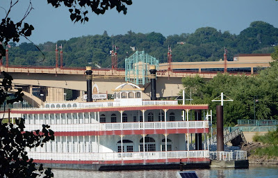
Along the island shore are tour boats.
Also in this area is the University of Minnesota Showboat. This boat is actually a barge and doesn't move from this site.
Harriett Island also holds an area often used for festivals during the summer.
I couldn't figure out what this event was until I saw the sight below.
Ah, a gondola. It must be the Italian Festival.
Our last stop was at Lower Landing.
From here down the river for 4-5 miles are many, many barges tied along the side. They are being collected to soon begin transporting the agricultural harvest that will soon begin.
Hope you enjoyed these scenes along the river.


No comments:
Post a Comment